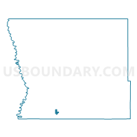
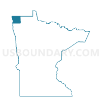
Donaldson Voting District, Kittson County, Minnesota
About
Outline

Summary
| Unique Area Identifier | 602767 |
| Name | Donaldson Voting District |
| County | Kittson County |
| State | Minnesota |
| Area (square miles) | 0.83 |
| Land Area (square miles) | 0.83 |
| Water Area (square miles) | 0.00 |
| % of Land Area | 99.87 |
| % of Water Area | 0.13 |
| Latitude of the Internal Point | 48.57442570 |
| Longtitude of the Internal Point | -96.89758240 |
Maps

Graphs
Select a template below for downloading or customizing gragh for Donaldson Voting District, Kittson County, Minnesota